FUTURE MOBILITY

Smart solutions for the future mobility

Products

Search
Field 7 Automated and autonomous driving and driver assistance systems
Back to field
A

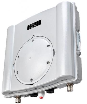
Advaced Perception demonstrator

Exhibits:
Yunex,s.r.o.
Location Pavilion A1 / 005

Autonomous delivery robot BringAuto

The robot can be remotely controlled by an operator (teleoperation) or can drive fully autonomously. Thanks to the modular design, it is possible to equip the robot with various superstructures, e.g. a superstructure for the sale of refreshments, a superstructure for cleaning of public areas, or a superstructure according to the customer's wishes. The robot can also transport material directly on the chassis, on which up to two Euro pallets can be placed. The robot has a load capacity of up to 700 kg and a maximum speed of 20 km/h. Robot is equipped with economical electric drive and lead or lithium-ion batteries, thanks to which the robot can last a whole day on a single charge. The compact dimensions (3000x1300 mm) predetermine the robot for operation in city centers and dense industrial and commercial areas. Autonomous driving and all safety features are provided by a combination of cameras, LiDAR and radars.

Exhibits:
BringAuto
Location Open air space D2 / 004A Open air space D2 / 004
F

Fleet management system BringAuto Fleet

It is possible to manage a whole fleet of robots with central application, change their destination and watch them on map. Our software solution is open source, therefore it is possible to integrate it to Smart City or industrial area systems with ease. Robots then can interchange information about the traffic density, quality of roads, their own occupancy rate and optimal route to destination with central system. Information about the robots and traffic can then be displayed by the city or the operator´s company. This communication, modularity of robot and electric drive supports the idea of ecologic and effective logistics of Smart City or industrial park.

Exhibits:
BringAuto
Location Open air space D2 / 004A Open air space D2 / 004
H

HERE We Go

HERE WeGo is a free navigation app that guides local and global travelers on journeys both familiar and foreign. The app now has a fresh, new design and clearer, easier-to-use navigation.

Enjoy a more carefree journey and reach your destination effortlessly, however you need to get there. Get there on foot with easy-to-follow walk guidance. Take public transport in more than 1,900 cities around the world. Or use turn-by-turn voice guidance with accurate driving directions and go by car. You can even find parking at your destination and get guided directly to it.

Visit the same places often? Save them in a collection to stay organized and find them easier. Or use shortcuts to get directions to them in one click.

Need to make an extra stop or want to go a specific way? Simply add waypoints to your routes and HERE WeGo guides you there.

Want to save your mobile data and stay on course even without an internet connection when traveling? Download a map of a region, country, or continent and complete your journey while staying totally offline.

Location Pavilion A1 / 027
I

INTIQ Platform

The INTIQ Platform by INTENS Corporation is a modular scalable software providing support for multiple areas of governance. Being offered as either on premise or cloud solution, it covers various functionalities in traffic control and monitoring as well as security. Its architecture based on independent functional modules and microservices provide scalability and robustness. Number of deployments for governance of city and national traffic systems testify our concept and effectively help provide better road conditions to drivers.

Location - / -

IoT luminaire for public lighting

The Alexia IOT luminaire is a widely applicable, energy-efficient LED luminaire that looks to the future. The design of the luminaire is characterised by gentle curves, smooth lines, a welcoming appearance and a slim design.

Through an API, the luminaire can be connected online to any back office system and can therefore be controlled and monitored remotely. The luminaire includes various sensors that contribute to easy installation, low maintenance costs and long lifetime - e.g. remote control, GPS, energy monitoring, accelerometer, temperature monitoring, etc.

In addition, the Alexia IOT luminaire is equipped with an advanced camera system with analytics in our Observer version. It includes 2 cameras with 226° of coverage (113° of coverage per camera). Video streams can be stored locally or transmitted via 4G or Wi-Fi wireless connection. With optional integrated "Edge computing" technology, video stream analysis can be performed. Audio clips can be played back using the optional audio speaker. The Observer camera accessory can be supplied as a standalone cartridge as an addition to an existing fixture. If the Observer add-on is needed at another location, it can easily be transferred to another location on a luminaire of the same type.

Exhibits:
Yunex,s.r.o.
Location Pavilion A1 / 005
L

Light signal controller

Modern Sitraffic sX controller for controlling traffic lights.
Low power consumption thanks to the unique 1W technology.
High safety and reliability.
Meets ISO 27001 cyber security requirements.
Easy and secure control via remote access.
Modular system that can be adapted to specific customer requirements.

Exhibits:
Yunex,s.r.o.
Location Pavilion A1 / 005
S

Simulator for urban vehicle preference solutions using ''V2X

Location Pavilion A1 / 003

Smart indoor navigation kiosk

The navigation kiosk is used to support navigation in buildings.
Visitor cards for turnstiles are replaced by smart cards that communicate with kiosks located at the corridor intersections, staircases and elevators in the building. When a visitor reports to the front desk the purpose of a visit to the building, the purpose is assigned to a specific visitor card in the system. If the visitor approaches the kiosk with it, a personalized navigation instruction is displayed (it disappears again when the visitor moves away). This allows the system to handle large numbers of visitors even though it has separate instructions for each one.
The navigation instructions are in the form of an arrow, a text instruction (for the blind it can be a voice instruction) and possibly also a video showing the section from the visitor's current position to the next kiosk (so the visitor does not need to know Czech and actually does not need to be able to read)
The kiosks allow the visitor to plan accessible routes and can react to dynamic constraints in the building (non-functioning elevator, closed corridor, etc.). Kiosks have support for mass events (no cards required) and for evacuation.
Other solutions are designed for buildings without controlled access, such as train stations, hospitals, campuses and other types of buildings.

Exhibits:
CEDA Maps
Location Pavilion A1 / 009
U

Ultra HD Mobile Mapping Vehicle

It is a special vehicle equipped with one of the most powerful mobile mapping systems in the world.
The car is used to create (Ultra) HD maps, which are essential for autonomous vehicles. It is currently involved, for example, in an autonomous tram project.
The vehicle is equipped with a pair of super-powerful LIDARs, a panoramic camera and a number of HD cameras, twin GNSS antennas, an odometer and a super-precise inertial unit.
In 8 hours of operation, the vehicle collects approximately 10 TB of data (10,000 GB of data). This is so large that it cannot be sent over the internet.
The vehicle also includes a data processing line that contains powerful data storage and software applications with artificial intelligence elements that can automatically locate objects such as trees, poles, girders, etc. in the measured data.
For comparison, imagine how long it takes a surveyor to locate 1 point on a plot of land with an accuracy of 14cm in 2D. A vehicle at 130km/h (even driving on cubes) locates 3.6 million of them per second in 3D and achieves an absolute accuracy of about 3cm under optimal conditions. Thanks to special techniques, even higher accuracy can be achieved and, same time, high accuracy can be maintained even in difficult conditions (e.g. in a tunnel).

Exhibits:
CEDA Maps
Location Pavilion A1 / 009
V

V2X RSU

Yunex Traffic's RSU2X Road Unit is the central interface for wireless communication between road infrastructure and on-board units.
Two-way communication via the RSU allows not only the transmission of information (e.g. speed limit) but also the reception of real-time messages. The RSU2X unit provides key data for a more accurate overview of the current traffic situation, and thus also contributes to more efficient traffic management and a significant reduction in the number of traffic accidents. The unit is characterised by high security and high computing power.

Exhibits:
Yunex,s.r.o.
Location Pavilion A1 / 005

Nastavení cookies

Ke sledování a analýze návštěvnosti na našich webových stránkách používáme soubory cookies. Tyto soubory mohou obsahovat osobní údaje. Pro některé účely zpracování takto získaných údajů je dle platné legislativy vyžadován váš souhlas.
Příjmout vše